|
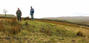
| *****SWAAG_ID***** | 466 | | Date Entered | 26/02/2012 | | Updated on | 26/02/2012 | | Recorded by | Ric Carter | | Category | Burial Mounds and Cairns | | Record Type | Archaeology | | Site Access | Public Access Land | | Record Date | 25/02/2012 | | Location | Muker Side | | Civil Parish | Muker | | Brit. National Grid | SD 90663 97372 | | Altitude | 1203 feet | | Record Name | Round Barrow at Muker Side | | Record Description | A small Round Barrow, with slight surrounding ditch, on sloping ground and commanding expansive views to the North, East and West | | Dimensions | Approx 6m diameter | | Image 1 ID | 2326 Click image to enlarge | | Image 1 Description | Round Barrow at Muker Side |  |
|
|
 |
|